
365Telugu.com online news,Hyderabad, April 12, 2025: In a significant initiative aimed at improving access to land-related information, the Hyderabad Outer Ring Road Area Authority (HYDRAA) has signed a Memorandum of Understanding (MoU) with the National Remote Sensing Centre (NRSC). This collaboration is expected to streamline and digitize vital geographic and land-use data within the Outer Ring Road (ORR) region.
The MoU was signed by HYDRAA Commissioner Mr. A.V. Ranganath and NRSC Director Dr. Prakash Chauhan at a formal event attended by senior officials from both organizations. The partnership aims to create a comprehensive digital repository of land boundaries, lakes, canals, drains, parks, and public utility areas.
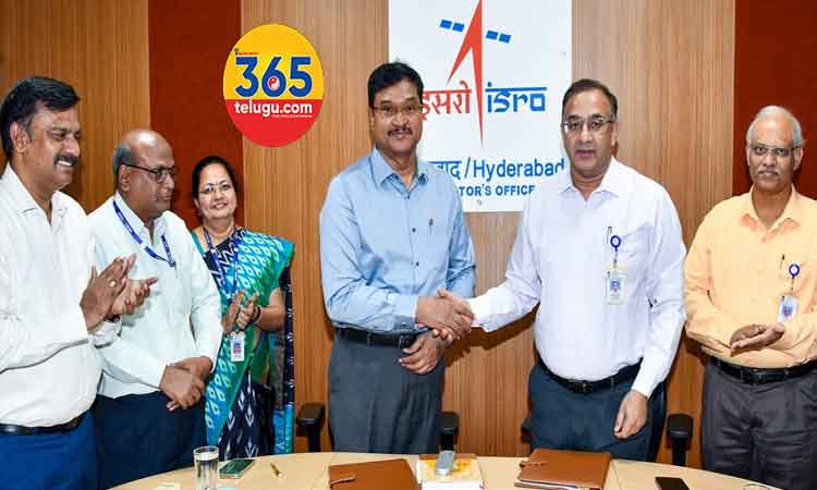
Mr. Ranganath emphasized that HYDRAA’s mission is to ensure complete transparency regarding Full Tank Levels (FTL), lake buffer zones, and other sensitive land areas. He stated that satellite data provided by NRSC, backed by academic expertise, would deliver highly reliable and precise geographic information to the public.
The MoU marks a key milestone in HYDRAA’s vision to integrate data from multiple sources — including Survey of India toposheets (1970), cadastral maps, revenue records, and satellite imagery — to prevent encroachments and support environmental sustainability.
Dr. Prakash Chauhan noted that Telangana is set to become the first state in India to undertake such a large-scale geospatial initiative focused on lake rejuvenation, government land protection, and sustainable urban development. He reaffirmed NRSC’s full support for the project.
Read this also…Swaraj Tractors Teams Up Again with MS Dhoni to Champion Farmers’ Prosperity
Read this also…Campa Signs Ram Charan as Brand Ambassador, Launches Inspiring New Campaign ‘Campa Wali Zidd’
Read this also…Tira Turns Two: A Bold New Chapter in India’s Beauty Evolution
MoU Highlights:
- NRSC will provide high-resolution satellite imagery, aerial photography, and Digital Elevation Models to HYDRAA.
- A dedicated geospatial portal for the Telangana Core Urban Region (TCUR) will be developed.
- Access to the Bhuvan and Bhu-Nidhi portals will enable the public to view historical satellite data and geospatial layers related to disaster management and water resource protection.
- HYDRAA will gain free access to NRSC’s National Database for Emergency Management (NDEM) for real-time disaster data visualization.
- Data integration will cover 27 municipalities and corporations surrounding the GHMC jurisdiction.